Hobart to Sydney
A long slog about a long trip — from Hobart to Sydney via everywhere in between. We tried to strike a balance between 'getting there' and 'stopping everywhere'. We made a few stops along the east coast of Tasmania, spent a few days around Flinders Island and could have spent much, much more time exploring, and then tried to enjoy the NSW south coast despite it's lack of decent all-weather harbours. Using the weather to our advantage we were able to anchor in some places that don't normally get visited by yachties. By nature, our stops were often just overnight stays and didn't provide much opportunity for exploration.
It was also a tiring trip with a fair amount of heavy weather once we left the protection of the Tasmanian East Coast. That stopped me taking photos because the Nikon D700 isn't at all waterproof! On the wish list is a smaller and more robust camera. However, there are some pics in the text and more pics in the gallery.
Enjoy!
Hobart to Riedle Bay 11 May 2017
We left the Royal Yacht Club of Tasmania in the early morning, well before dawn, to catch the tide at Denison Canal. The light arrived as we made our way down the Derwent, a beautiful dawn, and I am sorry to be leaving this wonderful town. We arrived at the canal about 1000 and called the bridge supervisor, who applauded our timing and agreed to open the bridge as we arrived. We motored past the open bridge and the long line or cars and trucks waiting for it to close again, and made our way through the canal and into Blackman's Bay at the far end.
Tide heights are Hobart tides plus 2 – 2.5 hrs. We had two high tides this day at 930 and 1214 Hobart Tides (say 1130 and 1414) which was very lucky as we arrived at the canal entrance about 1000 with a tide of .8m, giving us 2.6m of water at the lowest point of our transit. We draw 2m and so had 600mm under our keel.
Shallow points were at several places: in the lead up to the canal entrance, in the canal itself, and through the Narrows at the far end of Blackmans Bay. All these were measured at 2.6m.
MAST provide a recommended route on their website (http://www.mast.tas.gov.au/recreational/speed-operational-areas/bridge-transits-denison-canal/).
That night we anchored in Riedle Bay on Maria Island. This bay is open to the Tasman and thus a bit rolly. In hindsight we should have parked on the other side of the spit in Shoal Bay.
Riedle Bay Layday 12 May 2017
Overnight was cold and gray but no dramas. In the morning we took the dinghy to the beach and met Bob and Margaret off Shine who had dropped anchor in Shoal bay and walked across the spit. So we did the opposite and walked over the spit to Shoal Bay! It was pleasant enough but nothing remarkable.

Wallaby on Maria Island

Three of millions of dead or dying leatherjackets

Anjea in Riedle Bay
Here on the beach, and all along the east coast, we found millions of dead leatherjackets, some washed up on the beach, others dead or dying at sea. According to the experts they were dying of cold after being washed down south from warmer waters. Maybe that's why the bigger fish were not interested on our lures -- so many easy-to-catch leatherjackets.
The second night was more rolly and we both had trouble sleeping. I was glad to be underway in the morning.
Riedle Bay to Wineglass Bay 13 May 2017
We left Riedle Bay at 830 in light variable winds. A big bright ‘star’, brighter than any other, was off to the east. I said it was a satellite; Lesley claimed it was a super nova! Neither of us thought it was the second coming.
Sailed off the anchor but soon needed the engine. Motor sailed till 1000 which charged the batteries to -20A/H (-20 Amp Hour is over 80% charged) which compensated somewhat for lack of breeze. The predicted southerly was late in arriving.
Finally the wind arrived and we had a good sail till 1400 as the wind backed to the south, then dropped out. We motored past Half Lemon Rock and then Lemon Rock into Wineglass Bay.
A batten popped out of the main as we dropped it, which we fixed after we anchored using a shifter to align the batten with the car. The shifter made it easy but I guess increases the risk of breaking it!
Wineglass Bay turned out to be a great anchorage and we slept soundly – a nice change after the rock 'n' roll of Riedle Bay.
Wineglass Bay to St Helens 14 May 2017
We left Wineglass Bay at about 0400 for the 60 mile sail to St Helens. At 5 knots it might have taken 12 hrs but we averaged 5.75 knots and arrived a bit after 1400. We had a nice breeze from the south all the way. We were tempted to put up a spinaker but I was a bit wary of getting it down so we poled out the headsail instead.
In the relatively light southerly we decided to forego entering St Helens itself and instead anchored in Skeleton Bay, a beautiful spot just past the St Helens bar.
We jumped into the dinghy and motored around to the next bay, Binalong Bay, where there is a bit of civilization and a boat ramp. From there you can see the start of the Bay of Fires, an awesome stretch of sand backed by hills. The water is crystaline, the fish abundant (we are told by the locals) and the locals are friendly, as ever, in Tasmania.
Lesley bought a bottle of wine from a cafe. I went to bed before having any. Tired.
St Helens to Musselroe Bay 15 May 2017
The light southerly breeze continued into the next day. We awoke late, about 7, and after a slowish start motor-sailed up the coast in a placid sea. After an hour or so we turned off the engine and sailed the rest of the way to Musselroe Bay at well over 5 knots. The sea came up a little and the auto-pilot was slow at dealing with it. Several times, when a swell coincided with a gust it simply let the boat round up without attempting to correct the course. I need to experiment with different settings.
Dolphins everywhere. Common dolphins, they are called, fairly small with a white belly and dark top. Occasionally one would swim upside down under the bow wave. Was he eyeballing me as I hung over the rail? Or showing off? To me? Or to his mates?
Arrived at Musselroe Bay around 1215, earlier than anticipated.
I was feeling flat again so stayed in the dinghy while Lesley dived for fish. Her new-to-her drysuit proved to be warm enough but too ungainly to spear a fish.
Musselroe Bay has a cluster of houses and shacks at one end of the bay but no shops or facilities. On the other side of the bay is a wind farm.

Looking north past Shouten Island towards Lemon Rock in the distance
In the news, discovery of a new supernova in the Fireball galaxy. Lesley thinks she was right about the bright start several days ago, but they are saying it was invisible to the naked eye. The astonomer she contacted said she probably saw Venus. I am starting to think it's the second coming. Anyone seen any wise men around?
Musselroe Bay to Lady Barron 16 May 2017
The 50 miles across the first part of Bass Strait is easy sailing except for a nasty swell. The good wind makes it tolerable and it subsides after a while, once we are in the lee of Cape Barren Island.
We check out Harley’s Point on Cape Barren Island on the way. It looks like good protection from the south through west and a pretty aspect, with mountains in the background, but we continue on.
After a 0400 start we arrive at 1200 having safely traversed the Pot Boil Shoals and negotiated the leads into the harbour. It is a very tricky place! I most certainly would not want to cross in bad weather. The Pot Boil Shoal deserves its name with breaking waves to both sides and across the path. You basically just have to have confidence that your choice of tides, wind, and current are good, line up the leads and head into it. The leads and the charts agree with each other and tide, wind and current are all good so we plunge in. Instantly, we are dragged to the right by a strong rip and it’s a moment before we notice, but we claw our way back onto the leads and continue.
After the Pot Boil we weave our way through the Franklin Sound shoals, following the successive leads, managing to spot each of new set before we get to them, but we’re in clear daytime weather and wonder what it would be like in poor visibility, a truly frightening thought. A clear night would be easy as all the leads are lit, but radar and/or GPS would be essential in anything else.
At Lady Barron we pick up a MAST Mooring in 3.5m of water (about 2.5m LAT). The mooring is fairly convenient to the town, safe enough, but would be unpleasant in strong southerly weather.
We go ashore in the dinghy via the jetty and meet Lou Costello fishing on the jetty, who very kindly offers his ute to us to go to the store. We decline on the grounds we want to look about a bit and if the fish don’t bite he might want his ute back! He shrugs.
The store is OK, has fresh food and most food items. It is about 400m from the jetty up a slight hill. The locals are very friendly and helpful, but Lady Barron is a small place and there’s not much in the way of facilities. We did pass a tavern/cafe/restaurant on the way, and a Killiecrankie Diamond vendor, but the diamond vendor wasn’t home despite welcoming signs ushering us in. I did not contemplate stealing the diamonds while he/she was out!
The harbour master is Garth Smith, who informs us of bore water to the jetty or, he kindly offers, he will bring in his 500l tank if we wants fresh rainwater from the tank next to his brand new office, which just overflows every time it rains.
Diesel is available by calling the delivery truck, which will deliver fuel to Lady Barron or Whitemark.
Lady Barron to Badger Island 17 May 2017
We get up late and have a lazy start. Fix the batten that has jumped out of the car again. No wind, so we motor through the channel with a 4 knot tide helping us on our way. Glassy sea nearly all the way to Badger Island with just a hint of swell at the easterly entrance to Franklin Sound.

Cape Barren Island from Franklin Sound, on the way to Badger Island.
Lesley goes ashore and discovers a great many dead sheep in various stages of decomposition, and I bake some bread and pizza. Tonight is totally calm and we’re surrounded by clouds of insects: flies, moths, mosquitos, all sorts of flying crawling things – some are even on the surface of the sea. We hear a noise in the pitch black and I get the big spotlight. It’s a lone penguin paddling round the boat! He’s totally unconcerned by the huge light we point at him and simply continues in his perambulations.
Badger Island to Trouser Bay 18 May 2017
Bugger! We climbed Strzelecki Peak, but couldn’t quite make the top. We were a bit slack in the map department and forgot to download the online map of the walk, then forgot to snap the map displayed on a sign where we landed the dinghy, and so we were a little lost when we got to the main road. After walking a few hundred metres one way and seeing a No Through Road sign we figured it was the other way and set off without a clear idea exactly where the track started.
But angels exist. She is called Helen, lives on Flinders Island and is manager of the Mountain Seas Art and Wilderness retreat and just happens to be driving down the road with one of her employees as a new wave of indecision hits us. We flag her down to ask directions, which she happily supplies.
“You’re goin’ the right way.” she says “It’s just up the road after the second bridge.”
Thanking her profusely, off we go in our separate directions. Five minutes later she comes back, having dropped her employee off at a task, and offers us a lift, which we gratefully accept as we are running out of time after all our dithering. The walk to the peak is 5hrs return and it is already past midday.
After dropping us off at the track she turns around and goes back the way she came! We looked at each other – clearly she had come back just to give us a lift. Wow!
There’s a log book in a little stand near the start and I sign in.
We contemplate just who this Strzelecki character was: he has mountains, ranges, highways, creeks, deserts and lookouts named after him all over Australia. How does that work? It turns out he's a Polish explorer. See Wikipedia for more.
The climb to the top ofStrzelecki starts gradually and works its way up to a steep climb. It is only 2.8 km but rises 785m. It is an excellent track after experiencing Mt Rugby’s wombat trails, with cut steps and cleared wide paths that make it possible to walk side by side at times. Shortly after the start is a pretty creek crossing over stones. About half way we recross the creek through a beautiful dark rainforested gully covered by huge old ferns. Now the track gets steeper. And steeper. And steeper, until we are really struggling. On the way we decide the cutoff time has to be 1500. We will turn around at that time regardless. If we fail to do that then we will be swimming out to the dinghy in the dark – not an enticing prospect. As it is I expect to swim to the dinghy because the tide will be in, but I would rather do it in daylight.
As we approach the top the view opens up from magnificent to stunning with peaks on three sides of us and Bass Strait open to the west. But our legs are failing us and at 1450 Lesley calls a halt.
“Go on by yourself” she says, but I decline.
“No. Let’s call it a day” I say, reluctantly agreeing to a halt.
We are probably 100m from the top, vertically. My legs are jelly and I am starting to realize I was just not going to make it anyway. We have given it a decent shot and the walk is thoroughly enjoyable anyway.

Can you see a tiny white dot in the bay above the grarled old tree? That's Anjea.
Time to head back. We go down at what seems like twice the pace. Lesley spots another whipsnake (I saw one on the way up). The sun passes behind the northern peak as we come down, but when we finally get to the bottom and come out into the open it’s cloudy but bright.
Neither of us are looking forward to the long walk back to the boat. It’s about 5km of flat roads – easy walking – but we are stuffed. Lesley is for hitchhiking and is ready to put out her thumb for the first car. Unfortunately the first car is going in the wrong direction. But as it approaches we realize that it is Helen, the Island’s resident angel!
“Like a lift?”, she says throwing the door open.
We fall inside, old chums now, bubbling with gratitude at the heavenly intervention.
On the way back we discover she had again come to pick us up deliberately, timing her pickup perfectly to arrive just as we started up the road. We also discover she is a Tasmanian who loves the islands.
“Tasmania is the mainland, and for us Australia is ‘overseas’” she explains. Adding that she had once been to Sydney so she knew what a big city was like and that other people think she is odd for being so forward, and that’s just fine by her.
But if you grow up in a big city like me, people like Helen are something very special, like the fisherman on the wharf at Lady Barron who offered us his ute to go to the store, or the harbor master who offered to cart rainwater for us. No questions asked, someone in need, an opportunity to provide the obvious solution.
Helen drops us at the council-supplied free gas BBQ near our boat (remember, we are still pretty much in the middle of nowhere!) and we meet the crew of Top Day having a meal. They have anchored on the northern side of Trouser Point and we have the mooring on the south. Ian and Gary are crewing (or skippering?) for Sandy and her husband who own the yacht. They are heading for Bermagui rather than Eden because, Gary explains, Bermagui has better facilities.
Since then we’ve looked at the charts and sailing guides and decided that Eden is still probably a better bet for us, partly because Bermagui is reputed to be overcrowded and also because it is 40 miles further, but we can make a decision at the time.
The wind is picking up from the east. A bit after sunset I look for Top Day on the AIS and notice that they are moving from their side of Trouser Point to our side. Probably a good move on their part. They have no trouble anchoring in the dark next to us. I feel a bit guilty hanging off the MAST public mooring while they have to anchor but justify it by telling myself anchors are just as secure, or more so, than the average mooring, and anyway, public mooring etiquette dictates that he who has the mooring at 1500 can keep it overnight. Still, I leave the radio on and mark their anchor position on the chart, just in case, and check it during the night. Their anchor holds just fine.
The wind generator gets its best workout yet and we awake to almost-full batteries. Shortly after dawn, Top Day leave, heading north.
More bad weather is on the way and we have decided to stay so we spend the morning rerigging the mooring lines. The line supplied by MAST is too short. Anjea does not have a sampson post so we have to bring the line back to a cleat. There are two problems with that: first, it is so big it doesn’t fit through the fairlead; and second, if I take it over the bow rollers it is too short to reach the cleat.
I solved the problem on the first night by tying a heavy mooring line to extend theirs. That worked but was subject to chaffe and a single point of failure. Since there are rocks on the shore only 100m behind us, I can’t take any risk that the mooring line might fail and so we decide to double the lines and at the same time do away with knots and just have two looped lines that will be easy to drop when we leave.
Well, that was a great theory but the execution left something to be desired. It was cold wet and blowing, and the work had an element of danger, but that was no excuse for someone’s bad temper.
First we needed to rig another line to take the weight of the boat. To accomplish that we had to motor up to the mooring to take the line in, and secure a second line with a rolling hitch on the standing part. We couldn’t put it through the eye without jamming the first line in the bight.
We got it done and as we were taking up tension on the windlass Lesley pointed to my hands. I knew instantly that she wanted me to move my hands further back from the winch before she operated it. I dropped back a token six inches, but she wanted more. In typical bloke fashion I shouted at her to just *&^%$ do it! Not good. Anyway, we got it done.
The line I had tied on was secure all right – so secure I could not undo the knot even though the tension was now taken up by the rolling hitch. I was for cutting it, Lesley for undoing it. I cut it. Tension went up another notch.
Finally we have it done. What started out as a simple house-keeping task blew up into a difficult, unpleasant and badly executed exercise. Worse, I let my temper get to me. I knew that I should not have tied that mooring line on in the first place. Several lessons learned.
Talking this through later, I realized that I should have simply left the original knotted line until the weather eased.
That night, the weather eased and the boat happily bounced up against the mooring buoy, bok, ka-bonk, bonk, ka-bok… I got out of bed and undid all the extra mooring lines leaving just a single long line looped through the eye of the mooring line so the boat could fall clear of the mooring and I could drop one end and pull it through easily when we left. No further heavy weather is predicted. So back to sleep.
Next morning we prepare to leave and I proudly go forward to display how easy it now is to drop the line and of course the mooring line twists as soon as I let the tension off, trapping and binding my line in the eye. OK, I am slow. I finally realize this is a loser’s game, so I patiently call for a halt while I untangle the lines, and finally we are off. I hate moorings.
Trouser Point to Lady Barron 21 May 2017
I woke Lesley up this morning. “I had a nightmare last night that we were crossing bass strait and you refused to practice gybing” she said.
So today we practiced gybing. It’s a pretty basic manouver in light air but can get very dramatic and do damage to people and boat if you get it wrong in a blow. Also, with the new saloon-top bridle replacing the old cockpit traveller, we have less opportunity to finesse the gybe. I do not want to be in Lesley’s nightmare, so we head out to practice gybing.
After a dozen or so gybes we are both feeling more comfortable. I am taking a turn at the helm and we just finish a set of gybes and turn to claw our way up wind away from some shoals when I hear “fwiiiiissshhhh…. klonk… plunk” I turn to the sound but see nothing. We are ready for our next gybe practice session so I turn the boat and put the incident from my mind.
Practice improves until I start to lose concentration and get the direction of the wind wrong, turning into the breeze instead of away from it, which is worth 10 demerit points apparently. So we head for the entrance to Franklin Sound to start the trip to Lady Barron. As we go to drop the main sail Lesley says “Look, we’ve lost the lower batten!”
Now I know what a batten sounds like as it fwishes past your ear. It’s exactly the same sound as dropping two one-hundred dollar notes in the water.
We are off Lady Barron now, at the MAST mooring (this one has a longer line on it and no ka-bonking, yet). We dine on home made humous, our own sourdough bread from a mother we got in Dover (thanks, Jan) and a local Pinot Noir from Unavale Vineyard. Am I at the top yet?
Lady Barron Monday 22 May 2017
Today dawns blue and perfect for not sailing. We motor over to the wharf to fill the water tanks. Garth, the harbour master, provides the rainwater as promised and takes his tea break with us. There was a fleet of 35 small fishing boats working out of Lady Barron just a few years ago. Now there is one. The government has made it impossible for small fishermen to earn a living here so they have sold out, given up, or just moved on. It doesn’t seem right. Those fishermen supported shipwrights and their families, ran a fish processing plant, they purchased supplies, they spent money. Now they are gone and ‘tourism’ is the mantra. Well, no denying this is a beuatiful place, but I am sure most holiday makers would see Bali as a more attractive option. Getting here is difficult and expensive and the weather is unpredictable to say the least. Ecotourists might come in small numbers but a major tourist industry is just not on. In some ways I am relieved – at least the place is safe from being infected with the tourist disease.
Yesterday, a ute stopped as I walked up the road and a face popped out. In Lady Barron you cannot pass someone without passing the time of day. The face and I struck up a conversation and eventually we decided it was more economical to chat while he drove so I get in for a lift. Jon is an entrepreneur, originally from England, looking to start a barnacle farming operation. He knows the sea, and he’s done his research and it sounds impressive.
Today, we decide it would be nice to invite Jon to dinner so we flag him down as he passes our boat in his dinghy on the way to work and he agrees.
The roast chicken from the bottom of the Lady Barron Store freezer works out, despite a very short thaw and the gas bottle running out half way thru. Jon is a determined man with big dreams. Barnacles, it turns out, are a Spanish culinary speciality and he assures me they are very edible indeed. They are easy to grow, as every sailor knows, and all that he needs is some cooperation from the local marine industry regulators to make it work. He has aquired an aquaculture lease and is currently building the infrastructure, or ‘furniture’, as he calls it.
We have a great evening and end up talking music. Common ground is found in Jon Hopkins, Coldplay and Moby.
Lesley and I are preoccupied by the weather. Each new grib file is pored over to find the best window for getting across Bass Strait. We have a complex low coming our way, spinning off fronts and troughs that will cross Tasmania in the coming days. It looks like there is a window between the second and third fronts for a reasonably fast trip. Otherwise, we can wait another week for settled weather, but a slower trip.
Grib files are now our weather lifeline. GRIB files are the way weather information is distributed between meteorologists. They are compact and quick to download for any area in the world. For forecasts you can choose between a number of different models. I use the GFS model developed by NOAA simply because it was the one I started out with and I’ve stuck to it. But there are several others you can choose from, or you can get serious and compare the various models. Some people claim you should compare models and look for confirmation between them as a sign of high confidence, and discrepancies as a sign of low confidence. But I am not that sophisticated and simply try to understand what the GFS model is predicting and how that will pan out is sailing terms. We are confident in our ability to handle the boat in 30 knots of wind and 2 – 3 m seas, provided they are both behind the beam. We are cruising sailors so we want to avoid ever having to sail into weather like that, but it’s just fine behind us, pushing us in the direction we want to go.
So the GRIB files are predicting we will have 20-30 knots on Thursday between 2 fronts that are far enough apart for us to reach Eden. In fact the second front will peter out before Eden. So we’re starting to feel that this might be the one.
Lady Barron to Eden 24-25 May 2017
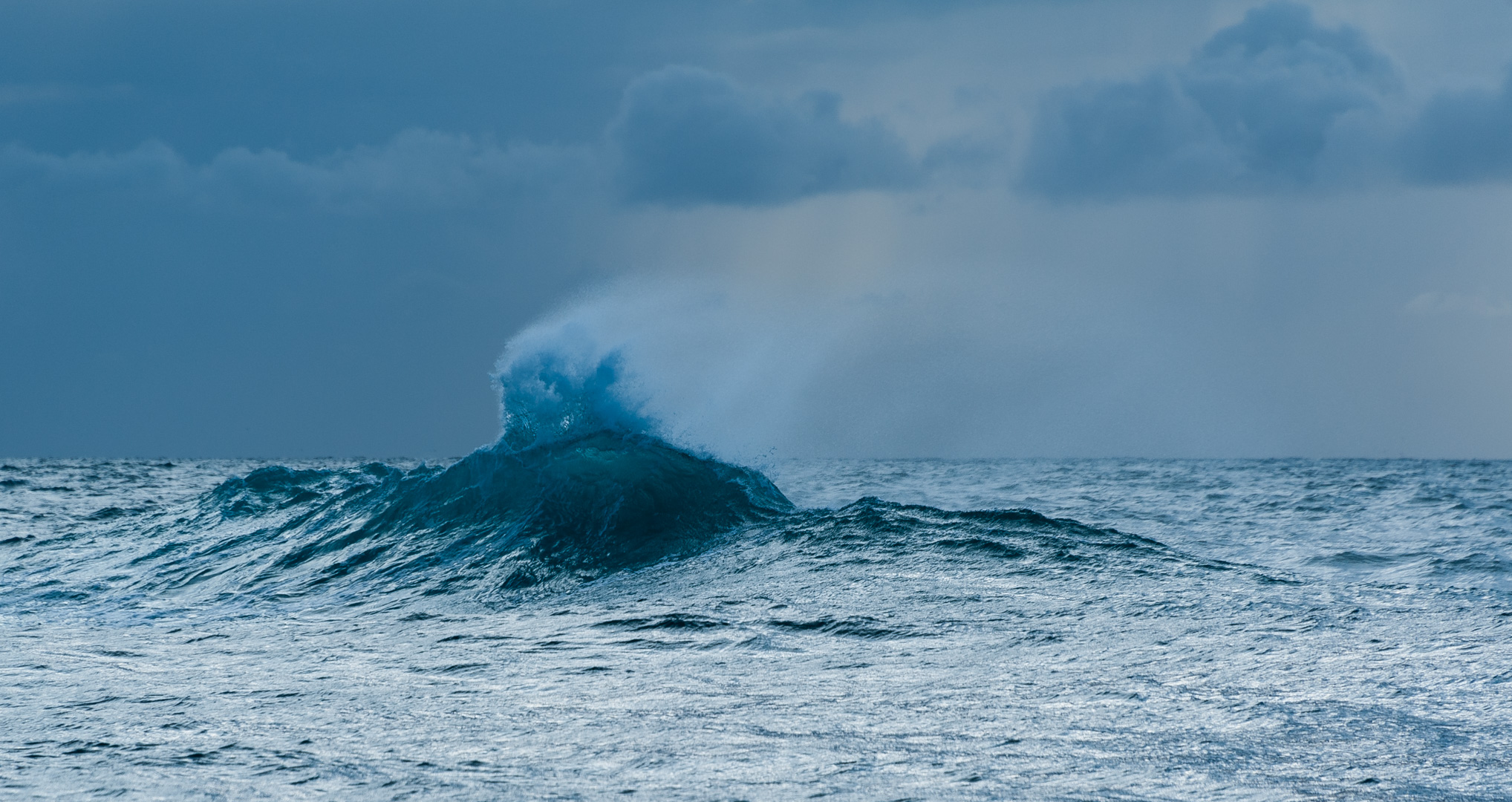
Leaving Lady Barron requires us to traverse The Pot Boil shoal again. As before, it is a frightening experience with steep waves rising out of nowhere in very shallow water.

The Pot Boil Shoal throws up steep nasty waves in very shallow water.
Bass Strait is behind us now and Green Cape, our landfall on the mainland, is a few miles ahead. The advice we had turned out right. Everyone agrees that you leave Tas on the back of a front so you get the southerly winds. In a system of three closely spaced fronts we left just BEFORE the second front, which was quite weak and passed us in the afternoon. Unfortuately, it was followed by winds every bit as strong as forecast, and with seas to match. But at least it was from a reasonable direction (SW).
It was a big strain on the boat but we made it. We had to hand steer in the afternoon and for most of the night, which is quite tiring on a black moonless night when you can’t even see the stars and your universe is reduced to this ghostly spinning black and green dial called a compass that constantly tells you that you are heading the wrong direction as the boat rolls, yaws and pitches you roughly in the direction you want to go. The autopilot caused the boat to round up and was unable to bring it back to course when the wind was over 30 knots, so we had to hand steer.
My theory is that the rudder stock is binding. The big seas and strong winds put so much strain on the rudder stock that it bends and that causes it to bind in the bearings. I am unsure if this is a design problem, a build problem or a maintenance issue and will need the assistance of an expert to diagnose it fully and come up with a solution. 30 knots is about when the BOM issue a Strong Wind Warning, the first level of wind warning (followed by Gale, and then Storm). We need to be able to steer in those conditions or we’ll be in real trouble. As it was I had one round up where the rudder just stuck fast and I was unable to correct despite applying enormous force to the wheel. Eventually, Lesley figured out that instead of brute strength you could give the wheel a little flick in the opposite direction and it would unbind, so that made it possible for us to hand steer.
The night was just one squall after another and Lesley was seasick (unusual for her) so most of the steering fell to me. Eventually, some time after 0400 the weather eased just enough for the autopilot to work again. But I didn’t trust it fully for another hour and continued to sit outside behind the wheel with my back to the rain and sea, until the cold and wet finally overcame my prudence and drove me inside. But I kept my wet weather gear on in case I needed to rush out and rescue the steering.
‘Rush’ is not really the right word. When the boat is heaving around like a wild thing you ‘rush’ at your peril. Instead, every move has to be planned so you have handholds and move to take advantage of the ship movement instead of working against it. At one point I was sitting in the setee and forgot to secure myself when the boat lurched and threw me at the wall opposite then lurched back the other way landing me on my back on the corner of the table. It still hurts.
Now the wind has died back to a few knots. The sun is shining brightly with just a few scraps of cloud on the horizon. To make progress I have started the engine and we’ll motor-sail the remaining 20 miles to Eden.
Lesley gave me an exercise for my neck called the McKenzie Chin Tuck, where I wobble my chin back and forth and, amazingly, it has helped a great deal with the sore neck I got staring at high stars to get a bearing last night.
Eden to Bermagui 28 May 2017
“I think the best weather for Bermagui will be Monday” I say.
“OK” says Lesley. “But we can sail on Sunday”
“Yes, but we will be close-hauled Sunday, and the wind swings west on Monday, so I think Monday is better.” I reply.
“We should go Sunday and if we don’t like it we can turn round and come back” she says.
I give up. “OK let’s go Sunday.”
The following day is Sunday so we leave and as soon as we get out there it is obvious we’ll be motor-sailing the whole way because it’s too tight to sail.
“We can stop at Merimbula” says Lesley.
There is nothing at Merimbula. It barely rates even a mention in the sailing guide because no yachts can cross the bar. It is, however, a tenable anchorage outside the bar in a northerly because of the headland. Since the wind is predicted to be from the west it won’t be ideal, but at least it should be safe. So I meekly agree and we pull in to Merimbula.
It’s now 2100 and calm enough with an offshore breeze. A strong wind warning is out for Eden and there is a gale warning further south, but it is OK here. I hope it stays that way overnight. I never sleep well when there is weather about.
Merimbula to Bermagui 29 May 2017
The anchorage is rolly but otherwise quiet with little wind. I awake refreshed and in a much better frame of mind, determined to have a better day today.
We correct a main sail car that I had rethreaded upside-down when we fixed a car jam problem yesterday afternoon, then hoist the main and sail off the anchor.
The Autopilot needs a name: Ghenghis? Donald? The one on my last boat was Desdemona because I always suspected her, but maybe I should be more positive and call this one Eudemonia as she has at heart our human welfare, though she does sometimes fail to deliver. Desdemona was Othello’s wife in Shakespeare’s play based on the Greek legend. Othello’s tragedy was that he suspected her. Eudemonia, on the other hand, is what Aristotle claims is the highest good for human beings. The trouble with that of course is that it’s impossible for human beings to agree on what ‘the highest good’ might be – everyone has their own ideas.
I notice what I think are birds diving. They must be big birds because the splashes are huge, but sailing issues takes my mind off this. The autopilot is giving up in the freshening breeze.
However, Lesley had good insight into the autopilot issues. She thinks the autopilot is giving up because of the rudder binding issue, and on reflection I agree it’s possible. She pretty much confirmed it today by giving the rudder a wiggle every time the a/p gave up and each time it freed the system.

A Whale off Burmagui
Just before we get to Bermagui Lesley shouts “Whales!”
The penny drops. They weren’t birds diving but whale blows I was seeing! We slowly gain on the pod and just before we turn in to Bermagui we are side by side with them. It is an awesome sight as they hugely surface, blow, dive, and are gone again until they do it again several minutes later. They don’t seem much interested in us, neither swimming towards or away from us, just continuing on in their steady, enormous way.
We get in to Bermagui at about 1500. I thought we had docking down pat now, after much discussion and experimentation, but once again I managed to get things wrong. I got angry at making mistakes and I took some of it out on Lesley. The only thing I can say in my defence is that I realized what I was doing pretty quickly and apologized. When I make mistakes that I know I just should not make (I rigged lines on the wrong side of the boat, to start with) it disorients me and the adrenaline starts to pump because I know I can’t afford to make mistakes like that. Anyway, conditions were mild and we got the boat in without any drama except the one I made for myself.
Lesley walks off and I finish the boat, go see the marina manager, say hi to the VMR guys, and meet up with her on the way back to the boat. She graciously accepts my apologies, and we lunch on the best fish’n’chips ever at the Fisherman’s Coop.
Bermagui to Broulee Bay 31 May 2017
The plan was to spend the night in the Moruya River. We got to the river OK and got over the bar without trouble, but as we made our way upstream we ran aground. Our options were to wait for a higher tide (we had arrived earlier than we calculated), to head for Bateman’s Bay (but that’s a barred entrance too and we would miss the tide), or the final option was to stop in an open roadstead anchorage such as Broulee Bay.
We chose Broulee Bay, which is quite large and open, easy to enter, and is reputed to be a good anchorage in southerly weather. It is, but it is also quite rolly. We are the only boat here, but there arer a few houses along the shore.
Broulee Bay to Ulladulla 1 June 2017
It’s official, the autohelm is now ‘Donald’.
Donald, we have discovered, is lazy, and works best on a ‘leisure’ setting. If you try the ‘performance’ setting Donald just can’t cut it. The other thing about Donald is his deceit: he seems to be doing ok, and then all of a sudden the boat is rounding up and all hell is about to break loose. To his credit though, Donald has only accidentally gybed once, and that was probably more our fault for not watching the wind as it moved aft while Donald was trying to steer a heading.
The Omlette and the Gybe
It is a beautiful sail north from Broulee Bay once we get around the headland. The flukey wind settles in from the aft quarter, we kill the engine, and are soon rocketing along at 6 to 7 knots. What’s more, Donald is doing great. We’ve worked out that he’s lazy and works best in ‘leasure’ mode, so that’s what he gets. We spend the morning inside, keeping watch from the saloon and wondering how we got to be so lucky as to be here on this beautiful day.
I decide on Spanish Omlette and salad for lunch and go below to start work. And of course the wind starts to pick up and the swell increases until we are doing over 8 knots in 4m waves. But I am determined to finish what I have started and brace myself in the galley against the gyrations of the boat. I have hot oil in the pan and the first 2 eggs whipped in a bowl, ready to go when WHAM! Donald gybes the boat. The bowl goes flying, spreading egg from one end of the galley to the other. Everything else, miraculously, stays more-or-less put, or at least lands in the same place, including the smoking hot pan of oil. Lesley is on top of it in a second and puts the boat on a safer course until after lunch. I clean up with someone’s bath towel (sorry Lesley) and it doesn’t take long to whip up some more eggs.
But it’s taken the shine off our beautiful day and we just gobble it down so we can get back to sailing the boat.
Ulladulla
Lesley and I both went to see the local VMR guys. Barrie, the operator on duty, was great and made us welcome to Ulladulla, explaining that we were the only boat today and that they had watched us all the way. He gave us a few pointers on how to find the leads next time, including that in daytime we should try to line up the clear open area in the town with Pigeon House Mountain, a prominent mountain inland that looks like a very female, very large, nipple, on top of a nicely shaped breast. It’s a good thing there is only one of them; if there were two the number of shipwrecks on this coast would be even greater.
Pigeon House Mountain was so named by Lieutenant James Cook in 1770 (he did not become Captain till after that voyage). The local aboriginals called it Didthul meaning woman’s breast. It says something about Cook that he didn’t see a nipple when it just about poked him in the eye. Where on earth did he get Pigeon House from? It’s Mount Tit or nothing!

The aboriginals called it Didthul (woman's breast); Cook called it Pigeonhouse Mountain. Who was right?
Ulladulla to Jervis Bay 2 June 2017
I expected to awaken to a battered boat. All night the noise of the ship surging back and forth against the fenders was excuciating. As it was, the damage was minor: just scuffed paintwork that should come good with a bit of vigorous cleaning. But still, it was an unpleasant night and neither of us got much sleep.
So we decided to cut short our visit to Ulladulla and move on to Jervis Bay. The sail up the coast is uneventful and Jervis Bay promises, and delivers, a fine, quiet anchorage. Lesley manages to contact some friends of hers, Peter and Angela, who live in Nowra, and they drive down to have dinner on the boat. We enjoy their company greatly.
Jervis Bay to Shoalhaven River 3 June 2017
In the morning we move up to Shoalhaven River. The sea is rough with 3 – 4m swells being refected back from the high cliffs north of Jervis Bay. Point Perpendicular deserves it’s name:

As we approach the Crookhaven River heads we hear activity on the VHF radio. Apparently some kayakers have got into trouble along the cliffs we have just sailed past. Apart from wonder at the foolhardiness of kayakers we were chastened not to have picked up the distress call. As it was, the local VMR were on top of it and rescued the paddlers. I resolved to turn up the volume on the VHF in future.
But I have done some ocean kayaking and it is amazing what can be done with strength, skill and endurance in such a tiny fragile vessel.

A peaceful sunset on Shoalhaven River, before the rain set in.
The river is a complex place with a man-made canal joining the Crookhaven River, through which we enter, to the Shoalhaven river. Berry’s Canal, which joins the two, was dug by convicts for the influential Mr Berry. With a draft of 2m we are unable to go far upriver, and there are low powerlines preventing us anyway, so we anchor off Greenway Point, a nondescript village about 7 nm from Nowra, and just inside the heads where Berry’s Canal meets the Crookhaven River.
The weather has turned liquid and I’m using the opportunity to ignore Lesley and concentrate on preparing for my Cox oral exam. We’ve had enough rain to fill one of the water tanks with run-off from the deck (nearly 300l).
Today is Wednesday. We have been here 4 days now awaiting the weather and are sick of it.
Shoalhaven to Kiama 8 June 2017
On a whim we decide to call Kiama Harbour to see if we can get a berth. The anwer is “Yes” so we set sail in a very light southerly breeze and cool sunshine – a welcome change after several days of solid grey. For once the tide is with us and we whizz out of the river at 7 knots, hoist the main, set the MPS (an assymetric spinaker good for off-the-wind sailing, but not ideal for a square run) and set off up the coast just as the breeze fills in.
We experiment with the MPS, deciding that the best way to rig it is with the mustard colored masthead halyard. Like a symetric spinaker, the MPS sails forward of the boat and so the lines all go outside everything else. We went at it slowly and when we finally hoisted it went up without a problem! Yes!
We immediately drop it to make sure we can get it down while the breeze is still light and then put it up again for the duration. We gybe a few times, managing to wrap the MPS ‘round the genoa more than once, but also managing to straighten things out. It was badly needed practice.
Off Kiama we drop the MPS as the wind starts to pick up, and try to get an idea of VMG going to windward. The wind is about 204° and 18 knots. We have a full main and genoa out and are overpowered. The sea is lumpy, mostly around 1m from the south but occasional larger waves when an easterly swell rolls in.
Kiama harbour is easy enough to enter by simply following the leads. Once inside there is not a lot of room. There are no floating pontoons, just bluestone wharves all round, with moorings off. The idea is you pick up a mooring and position the boat so it hangs a safe distance off the wharf. Then you rig a line to a ladder on the wharf and when you want to go ashore you just pull on the line to ‘warp’ the boat within jumping distance of a ladder and jump. Best not to look down.
We have the assistance of Trevor and while I was a bit slow picking up the details he was patient and we got it in the end. The result is safe but lumpy. There is quite a bit of remmant swell in the harbour and the short sharp movements of the boat as it tugs at the fore and aft moorings is tiring.
Looking forward to gettting to Port Hacking tomorrow.

The intimidating wharf at Kiama. But the mooring system is pretty good and holds the boat away from the bluestone walls.
Kiama to Port Hacking 9th June 2017
Well, I am in Port Hacking, Cronulla Marina to be precise and at $55/day it seems cheap just now simply to get access to civilization. The effect will wear off after a couple of days and the reality will hit me that it’s unaffordable. I have just been for a walk into the main drag and it’s certainly an upmarket place. I can understand why the locals rioted at the propect of being displaced from their incredibly comfortable existence by a bunch of Lebs (Lebanese from the western suburbs). Life is pretty good for them. Why share it?
Rows of great looking restaurants, cafes, health food shops, cafes, pure food shops, fashion shops, more cafes, surf shops, yet more cafes… you get the picture. Didn’t notice anything more mediteranean than Greek and Italian.
But that’s only the start because the place is surrounded by water: moorings and marinas on one side in the protection of Gunamatta Bay, and Cronulla surf beach on the other. In between is the Cronulla headland with rows of swank apartment buildings. The new ones look like jails with plate glass windows protected by huge chrome plated bars and locks. Obviously to keep out the Lebs. Or the Westies. The Abos got wiped out shortly after Bass and Flinders ‘discovered’ the place, but maybe the locals are afraid of ghosts. Or maybe it’s us yachties they fear.
The marina is almost completely filled with power boats. Big power boats costing squillions of dollars just to fill the tank. Still, they only need to squirt across Port Hacking to the National Park on the other side where they can turn up the stereo and party all night. Pity it’s mostly an 8 knot zone. Boy that must light some fires! Fancy purchasing your million dollar 1000 hp dream boat, only to discover you’ll get a ticket if you try to beat the jogger on the beach!
Of course it is mostly envy: I envy their deep pockets. But when I reflect on what they’ve had to do to acquire their wealth and I look at their habits around alcohol then the shine goes off their image and I am happy once again to be a poor yachtie.
Cronulla Layover 10 June →
It’s a Friday and Anjea and I have been in Cronulla Marina for one week. The news on the steering is not good. After an exchange of emails with Solimar in Italy it appears we need new parts. The crown gear is worn out and I need to replace the pinion gear and shaft as well. The parts are not too hideously expensive, but the freight is going to be a killer. Anyway, since I am going to be stuck here for a while I’ve decided to knock a few things off the TODO list. David, Allison and Natasha are going to make new covers for the boat. I met them more than 10 years ago when they lived on a yacht at Lizard Island. Now they run Covergirl Marine Trimming just up the road and I have been saving up a long list of projects for them to tackle.
Their reputation around the marina is awesome. I know they’re good but it’s really warming to hear how other people respond. If you are in Sydney and need upholstery, carpet, covers, or any other trimming repaired or made you just can’t do better than talk to Covergirl (https://covergirlmarinetrimming.com.au/). [Disclosure: I built their website].
Another great local business I’ve found is Ian Short Sails. They helped me out with a new batten and cars for the main. Ian is a down-to-earth sailor who knows his business. Also, he actually makes sails in his loft at Taren Point, as opposed to getting them made in Thailand like the big-brand sailmakers do.